The Highs and Lows of Christchurch's 360 Trail
By Sarla Donovan
By Sarla Donovan
Great Walk, or Just Great Idea?
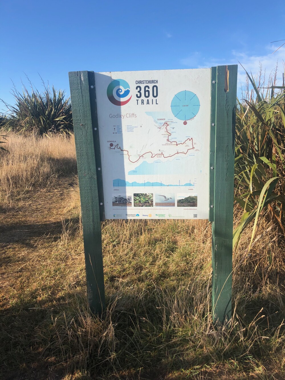
Christchurch people might have spotted this marker on posts, fences and walkways around the city and like me, wondered what it was. It turns out the markers delineate a route known as the Christchurch 360 Trail, a 130km pathway made up of eight sections, each able to be walked in a day.
Together, they form a rough circle around the city’s perimeter. This struck me as kind of neat! Volcanic rocks and marshy estuaries, surf beaches and pine plantations, braided rivers and bubbling brooks can all be found within the city limits and that’s what the trail tries to showcase: our diversity of landscape and habitat along with some history, architecture and culture.
It seemed like a mission for Rudy and me. Living near the Port Hills there are large swathes of the city I never go so it'd be good opportunity to explore outside my backyard. Autumn is usually a golden time of year in Christchurch - mellow and warm without summer’s driving easterlies and harsh sun. Perfect for finding out if this trail was really great, or just a great idea!
 The trail forms a rough circle around the city
Section 1: Godley Cliffs
Starting high on the Port Hills, I parked below the Gondola where Summit Rd is still earthquake damaged and closed to the west. Finding and following the trail markers was easy and perhaps it was the sunshine, or the earlyish (9.20am) start but this leg is a stunner. If you do just one part of the trail, make it this one. It’s 16 kilometres long but all off-road and though the website suggests 10 hours, Rudy and I did it in six, including an hour’s worth of stops.
The views of Lyttelton Harbour on your right and the city, alps and ocean on the left are breathtaking and as it’s a fairly steep start there’s every reason to keep stopping for breath. And photos. And sheep...
The trail sits atop the hill then hugs the eastern side as you get closer to the harbour mouth at Godley Head where we had lunch under the shade of some pines. From there it joins the Godley Head-Taylors Mistake track on the northern side of the hillside. There's a higher, less busy shared walk/bike track running just below the Summit Rd which is the option we took.
By the time we reached the sand it was pretty warm and Rudy raced into the waves to cool off. I wasn't hot enough for me to go in but if you go in summer definitely pack your togs. We headed down the end to the baches perched above the sea where the track takes you up some stone steps past the verandah of the first bach and then down onto second beach. You then climb up a grassy hillside towards Nicolson Park before following Flowers Track downhill to Scarborough, and an ice-cream from the Ocean Cafe. It's a fabulous walk full if you have a good level of fitness and great for dogs though you'll need to watch them around the sheep and bring extra water. We highly recommend!

Spectacular views of Lyttelton Harbour

Sheep! We came across quite a few, much to Rudy's delight

Godley Head and the historic WW2 gun emplacements. New murals by street artist Wongi Wilson are well worth a look

So beautiful! Looking towards Scarborough and the Southern Alps/Kā Tiritiri o te Moana

Is that beach I smell? Rudy anticipates a swim

A bach along the pathway

Looking back across Taylors Mistake to the hills we climbed earlier
Section 2: Estuary Marshes
I have to be honest here, this is section of two halves and the second is a pointless waste of time. It took Rudy and I five hours, starting at 1pm and finishing at the Pages Rd Bridge just before 6pm. No stops but I did take a wrong turn and got lost a couple of times which probably added 40 minutes to the total.
The first half is great. Start at Scarborough next to the Ocean Café (they have good coffee and cheese scones here if you're going in the morning) and follow the coastal pathway north along the esplanade. Wind around past Peacocks Gallop towards Rapanui/Shag Rock, through Moncks Bay then along Beachville Rd next to the estuary. Once you get to the Ferrymead Bridge, cross over to the hill side of the road and follow the tow-path behind Ferrymead along the marshy Heathcote estuary. I exited the path opposite Winnie Bagoes, crossed Ferry Rd and entered the Charlesworth Reserve via Waterman Pl.
That’s where it turns to shite. Unless you feel like meandering through rubbish-strewn parks, past the poorest of poor housing, through two gigantic cemeteries with headstones stretching on and on for infinity, through a creepy electric-fence-ringed pine plantation, alongside a stinking waste-water treatment plant and into a red zone wasteland – don’t bother!

The route takes you past Rapanui/Shag Rock

Heathcote towpath behind Ferrymead affords great views of the Port Hills

Cemeteries stretching on for infinity

Pine plantation near Pages Rd. It felt a bit spooky through here though Rudy didn't seem to mind

The trail takes you past the Nga Hau E Wha National Marae

I turned left into Shortland St instead of right, adding 35 minutes to the journey &*^%%%!
Section 3: Dunes-Wetlands
We started at the Bridge St bridge, a bit south of where you’re supposed to, but actually it's the best part of this stretch of the Avon. It’s where the river meets the estuary so there’s abundant bird life and some handsome, tall pine trees. Once you get up to the Pages Rd bridge where the trail actually starts it all gets a bit scraggly red zone again.
After about an hour walking beside the river you get to the Anzac Bridge, cross and continue alongside a super busy Anzac Drive until you arrive at Travis Wetland, a welcome oasis after the noisy traffic. It’s a shame the trail doesn’t take you through more of the wetland as it's quite lovely with bush and swamp vistas, but you soon pop out and for about 20 minutes you're meandering through the suburbs bordering Burwood Forest.
Burwood is a giant pine plantation and it's pretty monotonous. I tried to walk in the sun as much as possible and there was an easterly blowing as well so I was trying to get out of that which influenced my route through the forest. You could easily head straight down to the beach and walk along next to the dunes which would be prettier, but it was too windy for that. It seemed like Burwood Forest took an eternity to walk through because the landscape is so same-same.
For me the beginning and the end of this section were the two highlights. The final part takes you into Spencer Park where poplar trees grow in the sand and there’s a few rolling dunes before you come out into the big, grassy park.
It’s quick though, 16 kilometres and we did it in four hours including a lunch break.

Black swans are plentiful

The path takes you north-west along the riverbank for about an hour

Pages Rd bridge, where this section officially starts

'Poppies over Gallipoli' on the corner of Anzac Dr and Travis Rd

Sheep - on the alert for passing bordoodles near Travis Wetland


Burwood Forest, so many pine trees....

Nearly there: sand dunes take you through to Spencer Park
Section 4: Brooklands Mouth
This part has lots of water, you're off-road the whole time and it was somewhere I'd really never been so I really enjoyed it. You start at Seafield Park in Spencerville and follow the trail beside a lagoon. On your right there are dunes visible because you're not far from the sea and it's a pleasant open marshy/tusssocky landscape to walk through.
When we arrived at the old Brooklands subdivision it was easy enough to negotiate the empty, red-zoned streets out to the Styx River, where we walked along stopbanks before branching off through trees down to the mighty Waimakariri River. This is one of Canterbury's most iconic braided rivers, big and swift-flowing and lined with willow trees shedding their late-autumn leaves. I usually glimpse this river from a car window or an aeroplane so it was quite special to be walking beside it. There's a gorgeous landscaped park near the motorway bridge and walking under the thundering traffic was disorienting but kind of neat. On the western side of the bridge is White's Crossing where this section ends, but because it's only 10 kilometres long we kept walking for another hour or so before our ride picked us up near the quarry on Coutts Island Rd. We discovered some lovely, deep pools close to the river bank and away from the main flow which would be perfect for a dip in the summer.
Confession Time
So I'd done half the 360 Trail, winter was here and I didn't feel like walking the second half till it warmed up again. Can I say if it's a great trail, only having done the 180? I'd say the first section is fabulous and there are parts of the others that are worth doing, but as a coherent whole, it doesn't really work. It's difficult to get to to and from each section and there are some parts of questionable value, given all the other amazing walks in the Christchurch area. But I did discover some new areas of the city I'll definitely return to; and of course Rudy had a ball.

Brooklands Lagoon

On stopbanks near the Styx River

Poplar trees turning golden in late autumn

Splendid park near the SH1 bridge

One of us went in for a swim

Definitely returning to this spot beside the Waimakariri